Seasonal High Groundwater Table
(732) 291-5030
We find the depth to the Seasonal High Groundwater table for Builders, Developers, and Architects in New Jersey. Call for an Estimate.
We find the depth to the Seasonal High Groundwater table for Builders, Developers, and Architects in New Jersey. Call for an Estimate.
What is a seasonal high groundwater table?
The seasonal high groundwater table, often referred to as the "seasonal high-water table" or "SHWT," is the level at which the groundwater in a particular area typically rises during certain times of the year, such as the wet or rainy season. Groundwater is the water that exists beneath the Earth's surface in the spaces between rocks and soil particles, filling the pores and fractures in the subsurface materials.
The seasonal high groundwater table is not a fixed or constant level; it fluctuates throughout the year in response to various factors, including precipitation, temperature, and geological conditions. During periods of increased rainfall or snowmelt, the groundwater table tends to rise, and during drier periods, it may fall.
Understanding the seasonal high groundwater table is important for various reasons, especially for land use planning, construction, agriculture, and environmental management. For example:
Construction: Builders and developers need to be aware of the seasonal high groundwater table when planning and designing structures. High groundwater levels can impact foundations, basements, and drainage systems.
Agriculture: Farmers may need to consider the seasonal high groundwater table when deciding what crops to plant and when to irrigate. Excessive groundwater can affect crop roots and lead to waterlogging.
Environmental Impact: High groundwater levels can influence wetland formation, impacting local ecosystems and biodiversity. It's crucial to protect these areas, as they serve as habitats for various species.
Flooding: A high groundwater table can contribute to increased flooding risk, as the ground may become saturated more easily during heavy rains, leading to surface flooding.
To manage and mitigate the effects of the seasonal high groundwater table, monitoring and data collection are often necessary. This information helps authorities, engineers, and land planners make informed decisions about land use, construction, and water management in a particular area.
Link For: Groundwater Table Definition
Link For: NJ Division of Water Supply & Geoscience
Why do I need to know the seasonal high groundwater table when building an addition on my house?
Knowing the seasonal high groundwater table (SHWT) is important when building an addition on your house for several reasons:
Foundation Design: The depth of the Seasonal High-Water Table (SHWT) can affect the design and construction of your addition’s foundation. If the SHWT is high in your area, it may be necessary to design the foundation to sit above this level to prevent water intrusion. This could involve techniques such as raising the foundation on piers or using a higher water-resistant foundation type.
Preventing Water Damage: Building below the SHWT without proper precautions can lead to water infiltration into your addition. This can cause structural damage, mold growth, and other issues. Knowing the SHWT allows you to take preventive measures to keep your addition dry.
Drainage Planning: Understanding the SHWT helps in planning proper drainage systems around your addition. You may need to install French drains, sump pumps, or other drainage solutions to manage excess groundwater during the wet season.
Compliance with Building Codes: Many building codes and regulations require builders to consider the SHWT when constructing additions. Compliance with these codes is essential to ensure the safety and durability of your addition.
Cost Estimation: Accurate knowledge of the SHWT allows you to estimate construction costs more precisely. You may need to invest in additional materials and construction methods to address groundwater issues, and this can impact your budget.
Long-Term Stability: Building below the SHWT without proper precautions can compromise the long-term stability of your addition. Over time, water infiltration can lead to foundation settlement, which can result in cracks in walls, floors, and other structural problems.
Environmental Impact: Building below the SHWT without proper safeguards can have environmental consequences, as it may lead to the discharge of groundwater and potentially affect the local hydrology.
To determine the SHWT for your specific property, it’s advisable to consult with a geotechnical engineer or a qualified professional who can conduct site-specific investigations and provide recommendations for building safely and effectively. Taking these precautions can help ensure that your addition is structurally sound and resistant to groundwater-related issues, ultimately protecting your investment in your home.
Link For: Groundwater Issues in Construction
Why do I need to know the seasonal high groundwater table when constructing a new home?
Knowing the seasonal high groundwater table (SHWT) is crucial when constructing a new home for several important reasons:
Foundation Design and Placement: The depth and fluctuations of the SHWT can significantly influence the design and placement of your home's foundation. If the SHWT is high in your area, it may be necessary to design the foundation to sit above this level to prevent water intrusion into your home. This can involve using specialized foundation types or elevating the structure.
Preventing Water Damage: Building your home too close to or below the SHWT without proper precautions can lead to water infiltration, potentially causing structural damage, mold growth, and other moisture-related problems. Knowing the SHWT helps you take appropriate steps to keep your home dry.
Basement Considerations: If your new home includes a basement or crawl space, the SHWT is especially important to consider. High groundwater levels can lead to basement flooding and water damage, so it's essential to plan for effective waterproofing and drainage systems.
Sewer and Septic Systems: The SHWT can affect the design and installation of sewer and septic systems. High groundwater levels can make it more challenging to install septic systems or require special designs to prevent contamination or system failure.
Construction Costs: Accurate knowledge of the SHWT allows you to estimate construction costs more precisely. You may need to invest in additional materials and construction methods to address groundwater issues, potentially affecting your budget.
Local Regulations and Codes: Many local building codes and regulations require builders to consider the SHWT when constructing new homes. Compliance with these codes is essential to ensure the safety and longevity of your home.
Long-Term Stability: Building a home below the SHWT without proper safeguards can compromise the long-term stability of your home. Over time, water infiltration can lead to foundation settlement, which can result in structural issues and costly repairs.
Environmental Impact: Building below the SHWT without proper safeguards can have environmental consequences, as it may lead to the discharge of groundwater and potentially affect the local hydrology and ecosystems.
To determine the SHWT for your specific building site, it's advisable to consult with a geotechnical engineer or a qualified professional who can conduct site-specific investigations, including groundwater monitoring, and provide recommendations for constructing your home safely and effectively. Taking these precautions can help ensure that your new home is structurally sound and resistant to groundwater-related issues, ultimately protecting your investment and the comfort of your living space.
Link For: Groundwater Issues in Construction
What depth is considered a high-water table?
The depth at which a groundwater table is considered "high" can vary depending on the local hydrogeological conditions, climate, and regional standards. There is no universally fixed depth that qualifies as a high-water table because what is considered high in one area may be normal in another. However, some general guidelines can help provide context:
Relative to Foundations: In the context of building construction, a groundwater table is often considered high when it approaches or rises above the level of the building's foundation. This is because a high groundwater table can increase the risk of water infiltration into basements or crawl spaces, potentially causing structural damage or flooding.
Local Standards: Local building codes and regulations may define what constitutes a high-water table in your area. These regulations often specify the minimum required depth for foundations and septic systems below the groundwater table. The depth at which additional precautions or construction techniques are required can also be specified.
Depth Fluctuations: It's important to consider not just the static depth of the groundwater table but also its seasonal fluctuations. Even if the groundwater table is relatively deep during the dry season, it may rise significantly during the wet season, which can impact construction and building design.
Impact on Soil Properties: A high groundwater table can saturate the soil near the surface, making it more prone to erosion, settlement, and other stability issues. Therefore, what is considered high may also depend on the impact it has on soil properties and stability.
Local Expertise: Consulting with local hydrogeologists, geotechnical engineers, or relevant authorities is essential to determine what depth qualifies as a high-water table in your specific location. These experts can assess the local conditions and provide recommendations accordingly.
In some areas, a high-water table might be considered as shallow as a few feet below the ground surface, while in other regions, it may need to be significantly deeper to be considered high. Ultimately, it's crucial to assess the specific conditions of your building site and adhere to local regulations and expert recommendations when determining what depth is considered high for your particular project.
Link For: High Water Table
What is considered a high ground water table?
The depth at which a groundwater table is considered "high" can vary depending on the specific context and local conditions. There is no universally fixed depth that qualifies as a high groundwater table because what is considered high in one area may be normal or low in another. However, here are some general guidelines to provide context:
Relative to Foundations: In the context of building construction, a groundwater table is often considered high when it approaches or rises above the level of a building's foundation. This is because a high groundwater table can increase the risk of water infiltration into basements or crawl spaces, potentially causing structural damage or flooding.
Local Regulations: Local building codes and regulations may define what constitutes a high groundwater table in your area. These regulations often specify the minimum required depth for foundations and septic systems below the groundwater table. The depth at which additional precautions or construction techniques are required can also be specified.
Depth Fluctuations: Keep in mind that the groundwater table is not static; it can fluctuate seasonally and in response to weather conditions. What is considered high during a rainy season may not be high during a dry season.
Hydrogeological Factors: Local hydrogeological conditions, including the type of soil and rock, permeability, and groundwater flow patterns, can influence what is considered a high groundwater table in a specific location.
Historical Data: Historical data on groundwater levels in your area can provide insights into what is typical and what is considered high. Local hydrogeological surveys or monitoring programs may have this information.
Consultation with Experts: If you are uncertain about whether the groundwater table in your area is high or if it poses a risk to your property, it's advisable to consult with hydrogeologists or geotechnical engineers who specialize in groundwater assessments. They can assess the specific conditions of your location and provide recommendations.
In some areas, a high groundwater table might be considered as shallow as a few feet below the ground surface, while in other regions, it may need to be significantly deeper to be considered high. The key is to assess the specific conditions of your property and adhere to local regulations and expert recommendations when determining what depth is considered high for your particular project.
Link For: What is considered a high water table?
How do you determine the seasonal high-water table?
Determining the seasonal high-water table (SHWT) for a specific location involves a combination of data collection, monitoring, and analysis. Here are the general steps to determine the SHWT:
Consult Existing Data: Start by checking existing geological and hydrogeological data sources for your area. This may include local government agencies, geological surveys, environmental agencies, and academic institutions. They may have historical data on groundwater levels.
Installation of Monitoring Wells: If there is limited or no existing data for your specific location, consider installing monitoring wells. These are small-diameter wells designed to measure groundwater levels. Multiple wells may be needed to account for variations in groundwater depth across your property.
Measure Groundwater Levels: Equip the monitoring wells with instruments such as piezometers or pressure transducers to measure the depth of the groundwater throughout the year. These instruments can record data automatically at regular intervals.
Regular Monitoring: Continuously monitor groundwater levels over an extended period, ideally for at least one full year to capture the seasonal fluctuations. Groundwater levels tend to be higher during wet seasons and lower during dry seasons.
Data Analysis: Analyze the collected data to identify the highest recorded groundwater level during the wettest part of the year. This highest point represents the SHWT for your location. The SHWT can fluctuate from year to year depending on local rainfall patterns and other factors.
Statistical Analysis: Conduct statistical analysis on the data to determine the mean (average) groundwater level, as well as any trends or patterns. This can help you understand not only the SHWT but also the overall groundwater behavior in your area.
Consult Experts:
If you are unfamiliar with groundwater monitoring and analysis, it's advisable to consult with hydrogeologists or geotechnical engineers who specialize in groundwater assessments. They can assist with data collection, analysis, and interpretation.
Local Factors:
Keep in mind that local geological and hydrological factors can influence groundwater behavior. These include soil types, aquifer properties, geological formations, and nearby bodies of water.
Consider Seasonal Variability: Understand that the SHWT can vary seasonally. It's important to capture data over an entire year to account for these fluctuations accurately.
Determining the SHWT is critical for various purposes, including construction, site development, and environmental planning. Accurate knowledge of the SHWT allows you to make informed decisions about building foundations, drainage systems, and land use that take into account groundwater conditions and minimize potential issues related to high groundwater levels.
Link For: NJ Division of Water Supply & Geoscience
What is the average depth of the water table in New Jersey?
The average depth of the water table, including the seasonal high-water table (SHWT), can vary widely across different regions within New Jersey due to the state's diverse geological and hydrogeological conditions. New Jersey is divided into several geological provinces, each with its own groundwater characteristics.
In some areas of New Jersey, the water table may be relatively shallow, while in others, it may be deeper. The depth of the water table can also vary seasonally, rising during wet periods and falling during dry periods.
To determine the specific average depth of the water table in a particular location in New Jersey, you would need to consult local geological surveys, hydrogeological studies, or agencies responsible for groundwater monitoring. These sources can provide more accurate and up-to-date information for the specific region or municipality you are interested in.
Keep in mind that the depth of the water table is a dynamic and location-specific parameter, and it can change over time due to various factors, including climate, precipitation patterns, land use, and groundwater extraction. Therefore, it's essential to rely on local data and expertise for the most accurate and current information about groundwater levels in a specific area of New Jersey.
Link For: Current Conditions for New Jersey: Groundwater -- 26 site(s) found
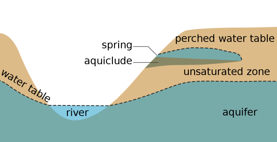
What determines the level of the water table?
The level of the water table, which is the upper boundary of the saturated zone below the Earth's surface where soil and rock are filled with water, is determined by a combination of natural and human-related factors. Here are the key factors that influence the level of the water table:
Precipitation: The amount and distribution of rainfall and snowmelt in a region have a significant impact on the water table level. In areas with heavy and consistent precipitation, the water table may be higher, especially during and after periods of rainfall.
Geology: The geological characteristics of an area, such as the type of rocks and soil, their porosity, permeability, and hydraulic conductivity, play a crucial role. Highly permeable soils and geological formations allow water to move more freely, potentially leading to a deeper and fluctuating water table.
Topography: The local topography or landscape features, including hills, valleys, and slopes, can affect the water table. In valleys, the water table may be closer to the surface due to the natural flow of groundwater downhill.
Proximity to Surface Water Bodies: The proximity of an area to rivers, lakes, ponds, and other surface water bodies can influence the water table. Groundwater may interact with surface water, causing fluctuations in the water table level.
Climate: Climate patterns, including seasonal variations in temperature and precipitation, impact the water table. Dry climates may have lower water tables, while wetter climates tend to have higher and more stable water tables.
Vegetation: Trees and other vegetation can influence the water table level through a process known as evapotranspiration. Trees absorb water from the soil and release it into the atmosphere through transpiration, potentially lowering the water table in the vicinity.
Human Activities: Human activities can have a significant impact on the water table. Groundwater extraction for purposes like drinking water supply, irrigation, and industrial use can lower the water table locally. Poorly managed or excessive groundwater pumping can lead to significant declines in the water table over time.
Land Use and Urbanization: Urban development, including the construction of roads, buildings, and impermeable surfaces, can alter the natural flow of groundwater and lead to changes in the water table's level. Increased runoff from paved surfaces can reduce groundwater recharge.
Groundwater Recharge: The rate at which groundwater is replenished or recharged influences the water table. Areas with ample recharge sources, such as permeable soils and infiltration of rainfall, may have higher water tables.
Seasonal Variations: Water tables often exhibit seasonal variations. During wet seasons, water tables tend to rise, while in dry seasons, they may fall.
Understanding and monitoring these factors is essential for managing and protecting groundwater resources, as well as for making informed decisions related to land use, construction, and water resource management in a given area. Groundwater professionals, such as hydrogeologists, play a crucial role in studying and managing the water table in various environments.
Link For: Groundwater sources that are under the direct influence of surface water
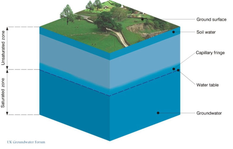
What are the 2 zones of groundwater?
Groundwater is typically divided into two main zones beneath the Earth's surface:
Zone of Saturation (Phreatic Zone): This zone is also known as the "saturated zone" or the "phreatic zone." It is the region beneath the Earth's surface where the spaces between the soil or rock particles are fully saturated with water. In this zone, all available pore spaces are filled with groundwater, and the water table marks the upper boundary of this saturated zone. The water in the zone of saturation is under pressure, and it is typically accessible through wells for various purposes such as drinking water supply, irrigation, and industrial use.
Zone of Aeration (Vadose Zone): Above the water table lies the zone of aeration, also known as the "vadose zone" or "unsaturated zone." In this zone, the spaces between soil and rock particles contain both air and some water, but they are not fully saturated. The water content in this zone can vary with depth and is often influenced by factors such as rainfall, evaporation, and percolation. Plant roots also extract water from this zone. The zone of aeration plays a vital role in processes like groundwater recharge and acts as a buffer between the surface and the saturated groundwater below.
These two groundwater zones are essential components of the hydrological cycle and have distinct characteristics and functions. The zone of saturation contains the primary groundwater resource, while the zone of aeration influences recharge, water quality, and the movement of contaminants between the surface and the groundwater table. Understanding these zones is critical for groundwater management, environmental protection, and various land use and construction activities.
Link For: 30 years of groundwater-quality data
Is it better to have a high or low water table?
Whether it is better to have a high or low water table depends on the specific land use, environmental, and geological context. Neither a consistently high nor a consistently low water table is universally better; it depends on the goals and requirements of a particular situation. Here are some factors to consider:
Advantages of a High Water Table
Groundwater Supply: In areas where groundwater is a primary source of drinking water or irrigation, a relatively high and stable water table can ensure a consistent and reliable supply of groundwater, reducing the risk of water scarcity during dry periods.
Wetland and Habitat Support: High water tables can create and sustain wetlands, which serve as important habitats for various plant and animal species. They also provide valuable ecosystem services, such as water purification and flood control.
Agriculture: In some agricultural contexts, a high-water table can be beneficial, especially in areas with crops that require consistent moisture levels. However, it's important to manage drainage to prevent waterlogging.
Advantages of a Low Water Table
Construction and Building Foundations: For construction purposes, a lower water table is generally preferred. It reduces the risk of groundwater infiltration into basements and foundations, which can lead to structural damage, mold growth, and other issues.
Septic Systems: A lower water table is often necessary for the effective operation of septic systems. High groundwater levels can interfere with the drainage of septic systems and lead to contamination.
Infrastructure Stability: Lower water tables can reduce the risk of soil erosion, instability, and subsidence in infrastructure like roads, bridges, and utility lines.
Land Development: Lower water tables can make land development and excavation activities more manageable and cost-effective.
It's important to note that water tables can fluctuate seasonally and in response to weather conditions, so the ideal depth of the water table may vary throughout the year. Additionally, proper management, such as groundwater monitoring, drainage systems, and sustainable land-use practices, can mitigate potential issues associated with both high and low water tables.
Ultimately, the suitability of a high or low water table depends on the specific needs and challenges of the area in question, and decisions should be made based on a thorough understanding of local hydrogeological conditions and environmental considerations.
Link For: Groundwater-flow model of the New Jersey Coastal Plain, 1980–2013
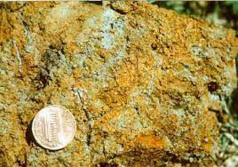
Soil Mottling
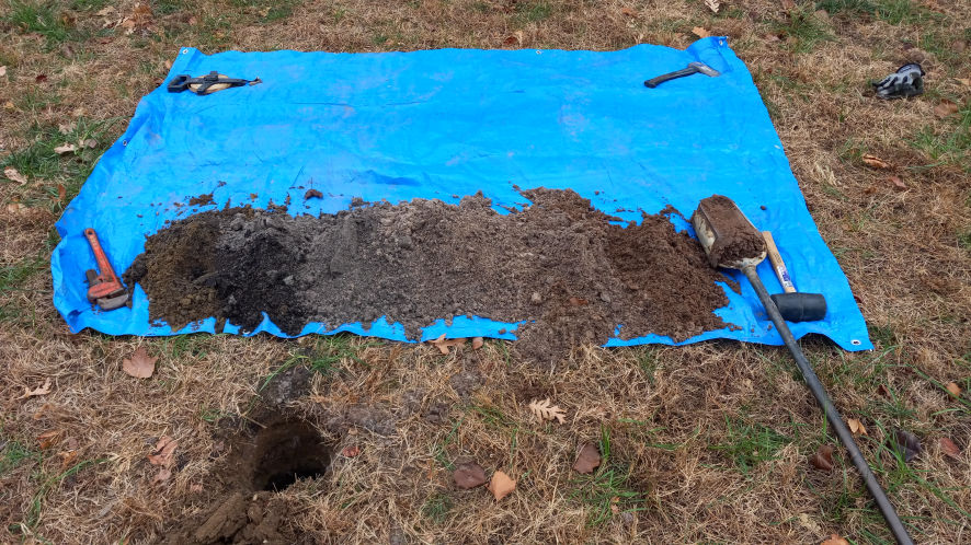
Knowing the depth to the seasonal high groundwater table allows a builder to determine the maximum depth of a foundation for a home or commercial structure. It also reduces the probability that the basement of a structure may flood because of rising groundwater over a year’s period of time.
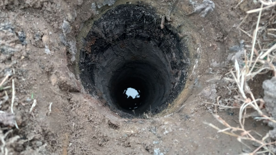
The time of year that the groundwater table is at its highest elevation is in the late winter and spring. During the summer the groundwater elevation is at its lowest point. Considering normal rainfall throughout the year. The method used to determine the seasonal high groundwater table is by completing soil borings. Within each soil boring the investigator looks for soil mottling in the soil boring profile. Soil mottling appears like a blotchy contrast in soil colors.
The groundwater table is defined as the upper limit of the where underground soil is saturated with water. It is the interface of where dry soil and saturated soil meet underground. The way that the depth to groundwater is determined is through soil borings. Soil borings are bored into the ground. As the soil boring is advanced soil conditions are monitored by the investigator. The investigator specifically looks for the depth to mottled soil conditions in the underground layers.
Normally if a home or structure is built with a basement floor below the seasonal high water table flooding can occur at some point throughout the year within the basement. Because rising groundwater can go above the basement floor slab. One of the ways to prevent the water table from entering a basement is to install a sump pump.
We Investigate underground soil & water conditions for engineering & environmental purposes.
© Copyright 2022 Tulmark, LLC. - All Rights Reserved